Pennock DJ, Zebarth BJ, De Jong E. 1987. Landform classification and soil distribution in hummocky terrain, Saskatchewan, Canada. Geoderma 40: 297-315.
These authors present a method of analysing irregular terrain for the purposes of examining important soil parameters such as soil depth and soil hydrology. Three variables (profile curvature, plan curvature, and gradient) can be calculated from a matrix of elevation data; taken together for a given point or area, these variables can be used to classify an area into one of seven landforms. These landforms are level (for summits or bottom lands), shoulders, backslopes, and footslopes; the three non-level forms come in “divergent” (convex plan) and “convergent” (concave plan) varieties. Shoulders have convex profiles, backslopes have flat profiles (i.e. constant gradient when looking up or down the slope), and footslopes are concave. Divergent landforms shed water laterally; convergent landforms tend to collect water. Where water collects and is moving slowly, rates of infiltration will be highest, and erosion will tend to deposit, rather than remove, material at these places.
The variables required to calculate profile and plan curvature and gradient are relatively easy to calculate from a matrix of elevation data, using an interpolating topographical software package and some differential calculus. The seven categories of slope elements can be estimated in the field by eye, making for a useful method for field studies.
This paper was on the recommended reading list for SLSC 834; in addition, the course instructor is Dr. Pennock, lead author of this study. The study site, near Hafford, Saskatchewan, is perhaps 1 to 1.5 hours drive away from Saskatoon, suggesting this area may be the destination of one of the day trips scheduled for the week of August 30, 2010.
Monday, August 23, 2010
Friday, August 20, 2010
Hayashi et al. 1998a
Hayashi M, van der Kamp G, Rudolph DL. 1998. Water and solute transfer between a prairie wetland and adjacent uplands, 1. Water balance. Journal of Hydrology 207: 42-55.
These authors report water balance data and analysis in the first of a pair of papers about the hydrology of wetlands in the prairie pothole region of central Saskatchewan. The second paper concerns dissolved material movements in the same example study system.
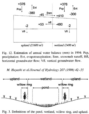
Through a series of measurements of water and water-related properties of soil as well as precipitation, total water balance and total water movements within the wetland were estimated. Direct precipitation and evaporation accounts for a small fraction of the total volume of water entering and leaving the pond in the middle of the hectare-scale wetland and surrounding catchment of uplands. Most of the water entering the pond is in the form of snowmelt during spring, and most of the water leaving the pond is in the form of horizontal groundwater flow, relatively shallowly (i.e. above a redox discontinuity at about 5-6m depth), driven strongly by evapotranspiration through the “willow ring” surrounding the pond and through crops (principally wheat during this experiment) on the uplands. Only a small amount of water is exported down to the aquifer; of a total input of 780mm into the pond, only about 3mm goes to recharging the underlying aquifer. Figure 3 provides definitions of the terminology, and Figure 12 the estimates of water balance.
 This paper was on the suggested reading list for SLSC 834 in August 2010.
These authors report water balance data and analysis in the first of a pair of papers about the hydrology of wetlands in the prairie pothole region of central Saskatchewan. The second paper concerns dissolved material movements in the same example study system.
Through a series of measurements of water and water-related properties of soil as well as precipitation, total water balance and total water movements within the wetland were estimated. Direct precipitation and evaporation accounts for a small fraction of the total volume of water entering and leaving the pond in the middle of the hectare-scale wetland and surrounding catchment of uplands. Most of the water entering the pond is in the form of snowmelt during spring, and most of the water leaving the pond is in the form of horizontal groundwater flow, relatively shallowly (i.e. above a redox discontinuity at about 5-6m depth), driven strongly by evapotranspiration through the “willow ring” surrounding the pond and through crops (principally wheat during this experiment) on the uplands. Only a small amount of water is exported down to the aquifer; of a total input of 780mm into the pond, only about 3mm goes to recharging the underlying aquifer. Figure 3 provides definitions of the terminology, and Figure 12 the estimates of water balance.
 This paper was on the suggested reading list for SLSC 834 in August 2010.
Thursday, August 19, 2010
Christiansen 1979
Christiansen EA. 1979. The Wisconsinan deglaciation of southern Saskatchewan and adjacent areas. Canadian Journal of Earth Science 16: 913-938.
This author describes in considerable detail the process of deglaciation that occurred at the end of the last glacial maximum from about 17 000 years ago, as it occurs to Saskatchewan. Major geological features and patterns of melt-water drainage led to the inclusion of nearby parts of Alberta, Manitoba, Montana, and North Dakota in the analysis. Patterns during the deglaciation were identified by glacial landforms, many of which are apparent only from aerial photographs, with sample analysis in the lab including radio-carbon dating.
The period from 17 000 years to 10 000 years ago is divided into 9 phases corresponding to periods of rapid glacial retreat or temporary stasis or glacial advance. By 10 000 years ago the ice sheet that had covered nearly the entire province had retreated towards Hudson Bay and covered only a small part of the north of Saskatchewan. Glacial lakes formed from meltwater and from water flowing from the west (presumably sourced from glaciers in the Rocky mountains), sometimes reaching enormous sizes; these lakes were bordered by the glacier’s edge, and connected to each other via spillways that often carved large channels from the plains; the east-west valleys of southern Saskatchewan such as the Qu’Appelle valley are the remains of such spillways. Modern river systems such as the Saskatchewan River and the Churchill River formed during the glacial retreat, occupying low areas and spillway remnants.
The rate of deglaciation varied considerably over the studied 7 000 years, generally accelerating from about 150 m / yr to around 275 m / yr, though with frequent pauses, occasional re-advances, and variation across the glacial edge. The evidence from glacial lake-edge movements and depth patterns suggests the ice sheet melted fastest initially, but with the slowest retreat at that time indicating the sheet first thinned, and then retreated, especially around newly-uncovered Nunataks where the underlying land formed highlands.
This paper was on the suggested reading list for the course SLSC 834 in August 2010, but it is also personally interesting in describing Pleistocene events in areas I visit during Sunday drives across the center of the province.
Tuesday, August 17, 2010
Wilkinson et al. 2009
Wilkinson MT, Richards PJ, Humphreys GS. 2009. Breaking ground: Pedological, geological, and ecological implications of soil bioturbation. Earth-Science Reviews 97: 257-272.
These authors describe the process of bioturbation in soils, and the roles of various major groups of organisms, especially animals, responsible for bioturbation. Through mixing and surface-mounding, bioturbation sorts, buries, and transports soil and soil components such as organic matter. Bioturbation also interacts with abiotic processes, particularly those involving surface water inputs and movements, to create net effects on soil movement and sorting.
There is a great deal of detail in the description of various sub-processes and rates, as well as some urging for more detailed studies of these phenomena. This paper is required reading for the course SLSC 834, in August 2010.
Monday, August 16, 2010
Johnson et al. 2005
Johnson DL, Domier JEJ, Johnson DN. 2005. Reflections on the nature of soil and its biomantle. Annals of the Association of American Geographers 95: 11-31.
These authors advocate a new paradigm to underlie studies of soil science and related fields, based on increased recognition of processes occurring in and responsible for the production of the “biomantle”, the upper layer of soil composed of and formed by the actions of organisms. Many of these processes are based on movements of soil and soil components, and so are dominated by animals, especially active burrowers that are responsible for large vertical movements of soil in some environments. The biomantle is defined as being composed of “biofabric”, or materials that owe their existence to the actions of organisms, from the bodies of these organisms themselves, to the materials released by the organisms, to the minerals created by biological processes, to the voids created by their movements and the gases filling those voids released by their metabolisms.
These authors trace their ideas from the writings of Darwin, particularly his final work involving the activity of worms in “vegetable mould”, a late-18th century term for what we now call soil.
A biomantle layer, residing chiefly in the A horizon (or topsoil) can be more easily recognized in some landscapes than others. Humid tropical soils especially may show very thick and distinct biomantles, in two layers. The upper, thicker layer is composed of relatively fine materials, resting on a basal layer of coarser material; this basal layer is referred to here as the stonelayer. Below the stonelayer is non-biomantle, typically a B horizon (or subsoil). The hypothesized process creating this two-layer biomantle is the action of “conveyor belt” animals, especially termites that carry small particles upwards but are unable to move larger stones, thus eventually sorting the soil mineral material.
In other soils, such as loess-derived sandy soils without a large component of gravel and larger stones, such a two-layer biomantle may not form, or may be very weakly developed and difficult to identify as such. Nonetheless, bioturbation activity by burrowing animals is usually apparent, for example in the form of “krotovina”, in-filled animal burrows.
Besides advocating for a view of soils and their processes with an animal-based, biomantle point of view, these authors spend some time dismissing subaqueous soils (e.g. marine sediments) as simplistic, uncomplicated places lacking many of the key (and very complex) processes that occur in subaerial soils. Their list of such processes near the end of the paper, taken as a kind of justification for their uncited and unsupported dismissal of subaqueous soils, is composed entirely of those processes relating to changing water amounts in terrestrial soils, such as groundwater flow and wetting and drying events. I found their argument unconvincing, as they do not describe any aqueous-only processes such as changes in dissolved-O2 concentrations or the sorting action of water currents, and their blithe disregard for marine biodiversity in statements about how much more diverse the life in terrestrial soils must be, is the proverbial icing on the insult cake. Johnson et al.: please cite some evidence to support such sweeping generalizations.
Subscribe to:
Posts (Atom)